Piet's Notes on Deep Creek Lake Science
Sensible Technologies - The Science of Deep Creek Lake
Bathymetry is the study of the depth of the waters in streams, rivers, lakes and oceans.
According to NOOA (the National Oceanic and Atmospheric Administration), “The term “bathymetry” originally referred to the ocean’s depth relative to sea level, although it has come to mean “submarine topography,” or the depths and shapes of underwater terrain.
In the same way that topographic maps represent the three-dimensional features (or relief) of overland terrain, bathymetric maps illustrate the land that lies underwater.”
In our case the focus is on the bathymetry of Deep Creek Lake, a 3,900 acre man-made body of water nestled in the mountains of Western Maryland.
Clearly, the bathymetry of the lake varies with the height of the surface of the lake. Since that height varies during the year because water from the lake is removed by the hydroelectric project, and augmented naturally by rain and runoff. The lake surface level typically varies during the year between 2,455 ft and 2,462 ft ASL.
Knowing how deep the water is at any given time can be very important for some people, especially when one lives in one of the shallower coves, mostly at the Southern end of the lake. This is because boats may not be able to float in their docks when the water level drops too much. This is the result of sedimentation in shallow coves that has become a concern over the years.
Determining the bathymetry of a body of water such as Deep Creek Lake is not difficult, but it’s also not trivial. It’s time consuming to get an adequate amount of data and to process the data into usable formats.
As one can well image, determining the bathymetry of the lake has been performed in the past but with the advances in technology and the changes in the impact of sedimention the bathymetry changes with time.
There exist several bathymetric maps of the lake that have been produced over time, the most recent one was generated by data obtained by DNR in 2012. Much on this websites is devoted to processing the data from those measurements and generating detailed maps of various coves, places where people typically park their boat docks.
Prior to the 2012 data set the MDE and USGS made measurements in 2007-2008 and produced a data set consisting of nearly 146,000 points.From these points they produced a regular grid of depths around the lake.
Prior to that there is the existence of “the Fishing map” which can be expanded to see the following map. The origin of the data on which it is based is unknown.
Another map showing water depth data is just called ’the Deep Creek Lake Map’. A reference to a portion of this map can be found here. According to this website “it was stowed away safely in the Railey Realty vault of ‘Deep Creek Lake Lore’” and digitized by Jay Ferguson, now a real estate agent at Taylor-Made Deep Creek Vacations. The whole map is no longer available at his website, but has been preserved as can be seen in the first link in this paragraph.
Another set of maps can be found by Bing supposedly at. But the website, humminbird.com, focusses on fishfinders and the map section of the website states that it provides maps of more than 10,00 in-land lakes in the US. (March 2022). The Humminbird Basemap does contain Deep Creek Lake (listing a lake area of 3898 acres. Presumable one can purchase a disk that has a detailed map of the lake on it.
The Bing search meantioned above resulted in an image of a section of the lake as shown in Figure 3.
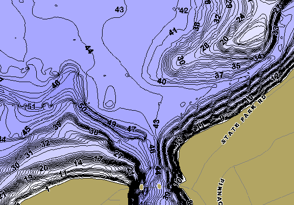
Figure 3. A Section of the Lake from a Humminbird Map